 https://www.technogis.co.id/wp-content/uploads/2024/10/rumah.png
394
487
Bintang Kejora
https://www.technogis.co.id/wp-content/uploads/2026/06/Logo-TechnoGIS-id-web-indonesia.png
Bintang Kejora2024-10-28 21:12:352024-11-04 08:19:58Denah Lokasi Rumah Saya: Petunjuk Arah Lengkap untuk Tamu dengan Mudah
https://www.technogis.co.id/wp-content/uploads/2024/10/rumah.png
394
487
Bintang Kejora
https://www.technogis.co.id/wp-content/uploads/2026/06/Logo-TechnoGIS-id-web-indonesia.png
Bintang Kejora2024-10-28 21:12:352024-11-04 08:19:58Denah Lokasi Rumah Saya: Petunjuk Arah Lengkap untuk Tamu dengan Mudah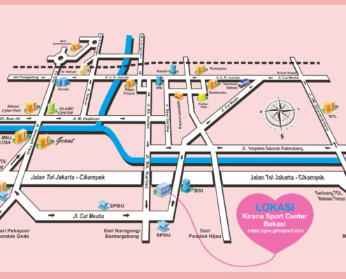 https://www.technogis.co.id/wp-content/uploads/2024/10/dedaa.png
528
875
Bintang Kejora
https://www.technogis.co.id/wp-content/uploads/2026/06/Logo-TechnoGIS-id-web-indonesia.png
Bintang Kejora2024-10-28 20:36:052024-11-04 08:20:51Cara Membuat Denah Lokasi Undangan Pernikahan: Desain Cantik dan Praktis
https://www.technogis.co.id/wp-content/uploads/2024/10/dedaa.png
528
875
Bintang Kejora
https://www.technogis.co.id/wp-content/uploads/2026/06/Logo-TechnoGIS-id-web-indonesia.png
Bintang Kejora2024-10-28 20:36:052024-11-04 08:20:51Cara Membuat Denah Lokasi Undangan Pernikahan: Desain Cantik dan Praktis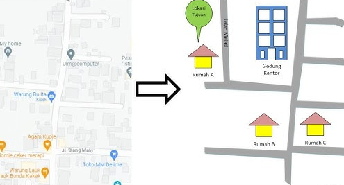 https://www.technogis.co.id/wp-content/uploads/2024/10/denah-rumah.png
267
564
Bintang Kejora
https://www.technogis.co.id/wp-content/uploads/2026/06/Logo-TechnoGIS-id-web-indonesia.png
Bintang Kejora2024-10-28 20:09:072024-11-04 08:21:35Denah Lokasi Undangan Rumah Saya: Petunjuk Arah Mudah untuk Tamu 2024
https://www.technogis.co.id/wp-content/uploads/2024/10/denah-rumah.png
267
564
Bintang Kejora
https://www.technogis.co.id/wp-content/uploads/2026/06/Logo-TechnoGIS-id-web-indonesia.png
Bintang Kejora2024-10-28 20:09:072024-11-04 08:21:35Denah Lokasi Undangan Rumah Saya: Petunjuk Arah Mudah untuk Tamu 2024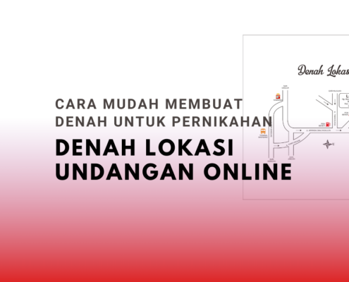 https://www.technogis.co.id/wp-content/uploads/2024/10/Cara-Mudah-Membuat-Denah-untuk-Pernikahan.png
720
1280
Bintang Kejora
https://www.technogis.co.id/wp-content/uploads/2026/06/Logo-TechnoGIS-id-web-indonesia.png
Bintang Kejora2024-10-28 15:00:122024-11-04 08:22:22Denah Lokasi Undangan Online: Cara Mudah Membuat Denah untuk Pernikahan
https://www.technogis.co.id/wp-content/uploads/2024/10/Cara-Mudah-Membuat-Denah-untuk-Pernikahan.png
720
1280
Bintang Kejora
https://www.technogis.co.id/wp-content/uploads/2026/06/Logo-TechnoGIS-id-web-indonesia.png
Bintang Kejora2024-10-28 15:00:122024-11-04 08:22:22Denah Lokasi Undangan Online: Cara Mudah Membuat Denah untuk Pernikahan https://www.technogis.co.id/wp-content/uploads/2024/10/denah.png
468
625
Bintang Kejora
https://www.technogis.co.id/wp-content/uploads/2026/06/Logo-TechnoGIS-id-web-indonesia.png
Bintang Kejora2024-10-26 22:00:342024-11-04 08:22:49Denah Lokasi Undangan Pernikahan: Panduan Lengkap untuk Membuat Denah 2024
https://www.technogis.co.id/wp-content/uploads/2024/10/denah.png
468
625
Bintang Kejora
https://www.technogis.co.id/wp-content/uploads/2026/06/Logo-TechnoGIS-id-web-indonesia.png
Bintang Kejora2024-10-26 22:00:342024-11-04 08:22:49Denah Lokasi Undangan Pernikahan: Panduan Lengkap untuk Membuat Denah 2024 https://www.technogis.co.id/wp-content/uploads/2024/10/ai.png
369
614
Bintang Kejora
https://www.technogis.co.id/wp-content/uploads/2026/06/Logo-TechnoGIS-id-web-indonesia.png
Bintang Kejora2024-10-26 21:41:582024-11-04 08:23:13AI Membuat Denah Lokasi: Teknologi Pintar untuk Membuat Denah Secara Otomatis
https://www.technogis.co.id/wp-content/uploads/2024/10/ai.png
369
614
Bintang Kejora
https://www.technogis.co.id/wp-content/uploads/2026/06/Logo-TechnoGIS-id-web-indonesia.png
Bintang Kejora2024-10-26 21:41:582024-11-04 08:23:13AI Membuat Denah Lokasi: Teknologi Pintar untuk Membuat Denah Secara Otomatis